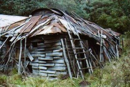
Strobridge Huts
Photo courtesy of Fiona Magnussen © 2003.
Known as Strobridges or Strobridge Homestead.
Located at Brookville beside the northern end of Charlotte Spur Track.
From Swifts Creek, follow Cassilis Road west for approximately 2.3 km, then turn onto Brookville Road and continue about 15.2 km to Charlotte Spur Track. Allow approximately 17.5 km driving to the turn-off.
Cassilis Road is sealed; the forest approach on Brookville Road includes gravel and may be corrugated or slippery after rain but is generally 2WD. Park safely clear of the Brookville Road–Charlotte Spur Track junction and walk approximately 35 m one way to the huts. Farther south, Charlotte Spur Track is steep and rocky 4WD terrain.
History
These huts survive from the former mining settlement of Brookville. Their early dates and builders are uncertain: older accounts give about 1895 for the rear hut and the 1920s for the front hut, while research published by VHCHA describes an 1880s miners’ bark hut and a front hut built during the Depression. The attribution of both buildings to the Strobridge family therefore needs qualification.
According to Sharyn Chambers’ 2018 account for VHCHA, Lucy Strobridge and her mother Ellen moved into the huts around 1950 after the family farm was sold. Ellen died in 1972. Lucy continued living here with support from local families and delivery drivers until her death in Omeo Hospital in 2001, aged 81. The front veranda was enclosed in 1980.
The huts survived the 2003 bushfires. Stories about Lucy’s ghost protecting them are local folklore. More work is needed to reconcile the early building chronology and confirm subsequent conservation work.
Construction
The old house is made from bush poles and iron. It now needs urgent attention after a wombat dug around one of the poles. A conservation study was completed for this hut in 2004. Has renovation been completed by 2026?
Caretakers - VHCHA
References
Hueneke, p. 244.
Magnussen, pp. 75–78.
Butler - none.
Mapping Guide:
GPS: 37.324417°S, 147.599383°E.
UTM: Zone 55H, 553104 m E, 5868970 m N. Approximate hut location (ExplorOz place 244805); source datum unstated, treated as WGS84.